Introduction
The name Elan was chosen for “urban watEr pLanning scenArios for sustaiNable cities”. It is a decision-support tool for the integrated management of urban waters (wastewater and stormwater) through nature-based solutions. ELAN is part of a broader objective to transform the cities of tomorrow, making them resilient to climate change. The challenge is therefore territorial, hence the relevance of resorting to a Geographic Information System (GIS).
One tool, two issues
Elan helps decision-making in relation to two issues: one specifically concerning wastewater (the centralized/decentralized question), the other involving urban water as a whole (the stormwater overflows question).
For the centralized/decentralized issue, the question is: how to connect an area without a sewer network (new neighborhood, area historically served by on-site sanitation)?
For stormwater overflows from a combined sewer system during rainfall, the user is faced with the question: how to limit the discharges of untreated water at stormwater overflows?
Illustrative examples
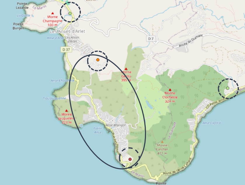
Centralized/decentralized question: Petite Anse (Martinique)
Petite Anse is a neighborhood with no sewer network: historically on-site sanitation was the chosen solution, largely due to geographic constraints (steep terrain).
The figure below illustrates the problem. Petite Anse (shown in the ellipse) consists of two interconnected zones (one low-lying and one on higher ground) connected by a road. The local authority responsible for this area wishes to study the feasibility of implementing a collective sewer system.
Several discharge points are possible:
one of the two existing wastewater treatment plants (green dots with dashed circles);
a new plant located in the neighborhood, either on the high ground (orange dot with dashed circle) or on the coast (burgundy dot with dashed circle);
a combination of these options (one new plant plus an existing one, or two new plants).
If all wastewater generated in this neighborhood is conveyed and treated at a single point, the management is centralized. If two (or more) outlets are used, the management is decentralized.
Elan helps the decision-making process by allowing users to explore and assess multiple scenarios.
Petite Anse will be a case study for the centralized/decentralized question : a tutorial focuses on it.
Stormwater overflows question: Écully (Rhône)
Hint
This section is under construction.
Structure of the tool
Elan is structured into several groups of modules.
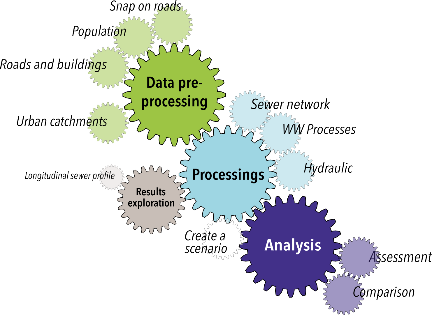
- Data pre-processing
Roads and buildingsthat allows the extraction of OpenStreetMap roads and buildings data for the user-defined area of interest.Population (uniform distribution)to assign the same number of inhabitants to each building based on a mean number of inhabitants per building.Population (areametric distribution)which is an alternative toPopulation (uniform distribution)and enables to adjust the number of inhabitants according to building footprint (number of inhabitants that varies from one building to another) based on a known total population.Snap on roadsthat can be used to snap each building centroid on the nearest road and thus facilitate sewer pre-sizing.Urban Catchmentthat identifies the various urban catchment areas drained by a known combined sewer network using pysheds.
Note
The use of these modules allows, if the user needs it, the preparation of the GIS data required as inputs for the “Processings” type modules: - Roads and Buildings, Population (uniform distribution), Population (areametric distribution) and Projection on roads for the Sewer network module, - Urban Catchment for the Hydraulic module.
- Processings
Sewer networkfor pre-designing a sanitation sewer network (separate sewer system, wastewater only) in an area without an existing network, using pysewer.Processesfor preliminary sizing of wastewater treatment systems of the constructed wetlands type, using wetlandoptimizer.Hydraulicfor estimating the volumes generated by the different urban catchments in an area.Create a scenariothat interfaces with the Processings and Analysis modules type and allows you to create scenario objects that can then be assessed and compared.
Note
The Sewer network module is used for the centralized/decentralized question.
The Hydraulic module for the stormwater overflows one.
The Processes module can be used for both issues.
- Results Exploration
Longitudinal sewer profilefor visualizing the underground profile of pipes (longitudinal view).
Note
The use of this module is optional. It allows, if the user wishes, a more in-depth examination of the results obtained from the Sewer network module.
- Analysis
Assessmentthat assesses a scenario according to several parameters (economic, technical feasibility, robustness).Comparisonfor carrying out a multi-criteria analysis on a set of scenarios and comparing them according to different criteria, based on user-defined prioritization.
A tool that combines different research projects
Elan aims to make the results of research conducted on the subject more widely accessible. As research projects are mainly focusing on a specific aspect of the issues addressed, ELAN allows to combine them to consider these two urban water management issues in their entirety and complexity.
The research identified and integrated into the current version of the tool has been developed by:


Among the future integrations into Elan is the urban hydrology research conducted jointly by:


The development of the tool itself currently involves:

This project is made possible through funding from: